Following reports that Bangladesh’s forestry agency had cut down dozens of trees in a major national park, Facebook users began sharing a photo of a highway running through lush green hills. According to them, this was an example of a mega-project that did not lead to deforestation. But the reports falsely claimed the photo was taken in Algeria, when in fact it showed a highway Brazil.
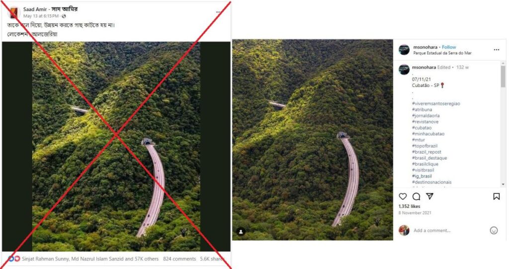
“Tell them that development doesn’t require cutting down trees. Location: Algeria,” reads the Bengali caption of one photo posted on Facebook on May 13, 2024.
The photo – which generated more than 57,000 comments and more than 5,600 shares – shows a road running through lush green hills.
The caption referred to the mega projects of the Bangladesh government, of which there are many causes concerns among environmentalists about its consequences deforestationa main driver of increasing temperatures around the world (archived links here And here).
The photo started circulates online after Bengali media reported the forest department has cut down hundreds of trees in the Altadighi National Park, located to the west of the country, for the development of a reservoir (archived link).
The same photo with a similar claim was shared elsewhere on Facebook here And here.
The claim is incorrect; the photo does not show a highway in Algeria, but was taken in Brazil.
Brazilian highway
A reverse image search on Google revealed that the photo was shared on November 8, 2021 from a Brazil-based company Instagram account (archived link).
The post’s caption read “07/11/21– Cubatão – SP” with hashtags including #topofbrazil and #visitbrasil.
The user of the Instagram account told AFP that the photo shows an aerial view of a point of “Rodovia dos Imigrantes” in the city of Cubatao in Brazil.
The photo “was taken in November 2021,” he told AFP.
Keywords on Google found details of the way on the website of Geodataan Italy-based civil engineering consultancy (archived link).
It says it shows Rodovia dos Imigrantes, a highway in the Brazilian state of Sao Paulo that connects the city to the Atlantic coast, and the coastal cities of Sao Vicente and Praia Grande.
Rodovia dos Imigrantes – which translates into English as ‘Immigrant Highway’ – is a highway in the state of Sao Paulo in Brazil.
According to the website, it first opened in 1974 Brazilian Institute of Geography and Statisticsrun by the country’s Ministry of Planning, Budget and Management (archived link).
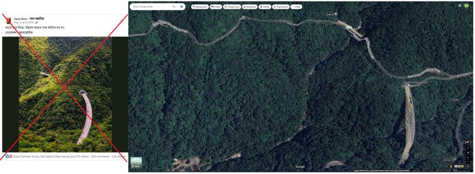
The photo shared in the fake post also matches Satellite view from Google Maps from the same location.
Below is a screenshot comparison of the photo shared in the fake post (left) and Google’s satellite view of the Rodovia dos Imigrantes (right):
